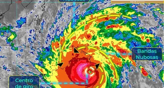
The SMN warns of the rains caused by the cold front 13 and tropical cyclone ‘Iota’ could generate an increase in the levels of rivers and streams, landslides and floods in low-lying areas.
MEXICO CITY.
The National Meteorological Service (SMN) foresees that this Tuesday heavy to intense rains will be registered in the southeast of Mexico and the Yucatan Peninsula, with torrential points in areas of Veracruz and Oaxaca, due to the cold front 13 in interaction with the cloud bands from tropical cyclone ‘Iota’.
The SMN warns in a statement that such rains could generate an increase in the levels of rivers and streams, landslides and floods in low-lying areas.
“THE COLD AIR MASS THAT DRIVES THE FRONT, WILL MAINTAIN A COLD ENVIRONMENT WITH FROSTS AT DAWN IN HIGH AREAS OF THE NORTH, CENTER AND EAST OF MEXICO, FOGS IN THE EASTERN SIERRA MADRE, AS WELL AS A VERY STRONG TO INTENSE” NORTH “EVENT ALONG THE ALONG THE COASTLINE OF THE GULF OF MEXICO, ISTHMUS AND GULF OF TEHUANTEPEC ”, IS DETAILED IN THE TEXT.
November 17, 2020:
- Intense rains with punctual torrential rains (150 to 250 mm): Veracruz (south and central mountainous area) and Oaxaca (north).
- Very heavy rains with intense punctual rains (75 to 150 mm): Puebla, Tabasco and Chiapas.
- Heavy rains with very strong punctual rains (50 to 75 mm): Hidalgo and Campeche.
- Intervals of showers with strong punctual rains (25 to 50 mm): Tamaulipas, San Luis Potosí, Querétaro, Yucatán and Quintana Roo.
- Intervals of showers (5.1 to 25 mm): Guerrero.
- Isolated rains (0.1 to 5 mm): Nuevo León, State of Mexico, Mexico City and Tlaxcala.
While during this night and early morning, the interaction of the cold front number 13; same that runs through eastern Mexico, with a low pressure channel over the southeast of the country, causes persistent rains with torrential accumulations (150 to 250 mm in 24 hours) in areas of Veracruz (center and south), Oaxaca (north and east ), intense in Puebla, Tabasco and Chiapas; very strong in Campeche, as well as strong occasional rains in Tamaulipas and San Luis Potosí.
Said rains could be accompanied by electric shocks and strong wind gusts, in addition to generating an increase in the levels of rivers and streams, landslides and flooding in low areas of land.
On the other hand, the mass of cold air associated to the front will cause a drop in temperature and fogs in the north and center of the country, as well as a “North” event with gusts of 90 to 100 km / h on the Isthmus of Tehuantepec, swell 3 to 5 meters high in the Gulf of Tehuantepec; gusts of wind from 70 to 80 km / h on the coast of Veracruz and from 50 to 60 km / h on the coast of Tamaulipas, Tabasco and Campeche.
“THE CENTER OF HURRICANE” IOTA “WILL ENTER LAND DURING THE NEXT HOURS ALONG THE COAST OF NICARAGUA. ITS WIDE CIRCULATION WILL INCREASE THE RAIN CONDITIONS IN AREAS OF YUCATAN AND QUINTANA ROO ”, IT IS MENTIONED IN THE STATEMENT.
jcp
Copyright law strictly prohibits copying all or part of Excelsior’s materials without having previously obtained written permission and without including the link to the original text.


