Struggles with Chichén Itzá triggered its decline, but the city was occupied into the 1500s
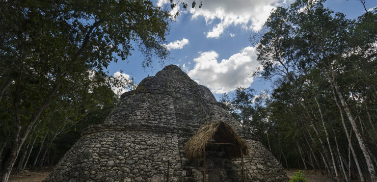
Cobá is considered one of the most important ancient Maya cities in the present-day Yucatán peninsula. Situated within a day trip’s distance from Cancún, Playa del Carmen and Mérida, and just 47 kilometers from Tulum, the site is surrounded by jungles and lakes and is close to a few cenotes.
Cobá was first mentioned in contemporary texts by American explorer John Lloyd Stephens in 1842, although the National Institute of Anthropology and History (INAH) says that he did not visit the site. In 1886, a former director of the Yucatecan Museum, Juan Peón Contreras, visited Cobá, but important archaeological explorations there did not begin until the 20th century.
Cobá is a city that has maintained its original name — Mayan for Chopped Water. The first settlement — thought to have consisted of small villages around lakes — dates to between 100 B.C. and A.D. 300. The city peaked in development during A.D. 600–1000, and Cobá had maintained relations with other Maya cities in the Petén — in Guatemala — as well as in Mexico during the Mesoamerican Classic Period.
Around A.D. 900–1000, Cobá entered a power struggle with Chichén Itzá and was defeated. While its power declined after, the city continued for several more centuries and was eventually abandoned around the 16th century.
Cobá extended to over 70 square kilometers with an extensive road network of about 50 white roads — elevated roads with a white surface. Two significant roads include a 100-kilometer road to Yaxuná, a Maya city close to Chichén Itzá, and a 20-kilometer road to the Ixil in Yucatán. The main area of the city was surrounded by five lagoons, and there are two notable lakes — Lake Cobá and Lake Macanxoc — by the archaeological zone.

During its peak, Cobá’s population is thought to have been over 50,000. INAH says archaeologists have identified 14 rulers who guided Cobá to its grandeur. A female ruler named Ixik … Yopaat (the ellipsis indicates where letters were illegible in the ancient reference to her), who ruled for 40 years in the early seventh century, is noted as one of the most important.
You will enter the archaeological zone by beautiful Lake Cobá. There are four main groups of buildings and many other structures distributed across the site. Hence, prepare for some extensive walking. You can also rent a bicycle or a bike taxi to explore some areas of the site.
By the entrance is the Cobá Group, identified as the oldest section with over 50 structures and several stelae — carved or inscribed stone slabs or pillars. Six white roads begin and end in this group.
A significant building here is the nine-tier pyramid called The Church with its temple on top measuring over 24 meters in height. The Church is the second tallest building on the site. A stela and an altar sit in front of the pyramid, and it is speculated that some people in the area still worship the stela, which they believe represents a virgin called Colebí. Unfortunately, climbing this pyramid is not allowed.
The plaza in front of the pyramid is thought to have held religious and other everyday activities. Next to it is an interesting structure with a vaulted passage below its stairway.
A must-see in this group is the ball court — one of two on the site. The ball court has two parallel buildings with ball rings, but, notably, panels on the walls with figures of prisoners.

North of the Cobá Group is the Group D buildings. A highlight in this area is the Paintings Group, which features the Temple of the Paintings — a pyramid structure with a temple on top that has remains of murals. Climbing this building for a closer view is unfortunately not allowed.
The second ball court is also in Group D, which has the prisoner-figure panels as well as two markers of stone carvings in the playing area. One marker is identified as a skull, and the other an animal — possibly a jaguar.
An absolute must-see in this section, however, is the distinctively shaped four-tier pyramid called Xaibé — Mayan for Crossroads. Several white roads connect by this pyramid, whose exact purpose is unknown, although there is speculation it was an observatory.
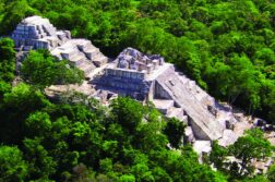
North of Group D is the Nohoch Mul Group, with its famous Nohoch Mul Pyramid. Nohoch Mul is Mayan for “great mound.” Only a few of the Nohoch Mul Group buildings have been explored.
This seven-tier pyramid is the tallest building on the site, measuring around 40 meters tall and featuring a temple on top. The crowning temple has images of the “Diving God” — a god portrayed upside-down.
A second stairway of the pyramid leads to a room on a lower floor thought to be a temple. While climbing is usually allowed on this pyramid, it was cordoned off when we visited due to the ongoing pandemic. In the plaza to the south of the pyramid is a notable stela, considered the best-preserved of the site and said to depict a ruler.
East of the Cobá Group and Lake Macanxoc is the Macanxoc Group of buildings, considered mostly ceremonial in purpose. There are multiple buildings on a platform, eight stelae and several altars worth seeing. Archaeologists have yet to explore some of its structures.
The shady atmosphere makes exploring a pleasant experience despite the warm temperatures almost year-round. We spotted many beautiful birds and monkeys in the surrounding wilderness while there.
Once you’re done exploring Cobá, refresh with a swim at one of the area’s three nearby cenotes — Choo-Ha, Tankach-Ha and Multum-Ha.
Thilini Wijesinhe, a financial professional turned writer and entrepreneur, moved to Mexico in 2019 from Australia. She writes from Mérida, Yucatán. Her website can be found at https://momentsing.com/


